Where Every Road Tells an Ancient Story
The Royal Enfield’s engine echoed through the mountain pass as I crested the final ridge, and suddenly there it was—Tawang Monastery emerging from morning mist like a golden vision that had been waiting centuries for this exact moment. Standing at 10,000 feet, surrounded by peaks that guard secrets older than written history, I finally understood that some journeys don’t just take you to places—they take you to stories that have shaped the soul of the land itself.
But this realization didn’t come immediately. It began three days earlier when I discovered that my GPS might show routes, but only legends show the true spirit of a place. Every destination in Tawang carries an ancient story: a monastery built where a divine horse chose to graze, a lake born from catastrophic tragedy, a waterfall named after a girl who helped defend India’s borders. This wasn’t just scenic touring—this was riding through living mythology.
Trail Overview: Where Legends Live
The Tawang circuit offers something rare in modern travel: destinations where ancient stories still breathe through the landscape. This route connects sacred architecture with natural wonders, each stop revealing how local communities have woven meaning into geography for centuries.
Essential Stats
- Total Distance: 350+ kilometers over 3 days
- Altitude Range: 8,000-15,200 feet
- Difficulty: Advanced (high altitude, border area)
- Best Season: March-October
- Special Requirement: Inner Line Permit mandatory
Why This Route Transforms Storytellers
You’re traveling through landscapes where every mountain, lake, and waterfall carries legends that local communities have preserved for generations. From Buddhist mythology to earthquake folklore to war heroism, each day unveils stories that transform scenic stops into sacred encounters with living history.
Day-by-Day Legend Discovery
Day 1: The Divine Horse Legend – Tawang Monastery
The morning mist cleared as I approached Tawang Monastery, and the legend began revealing itself in the landscape. According to local tradition, this monastery—the largest in India—sits exactly where a divine horse belonging to Mera Lama Lodre Gyatso chose to graze in the 17th century.
The Legend Unfolds: When the lama’s horse wandered off during his journey through these mountains, he followed its tracks for days. When he finally found the horse grazing peacefully on a high plateau, surrounded by natural springs and protected by mountain walls, he understood this was divine guidance. The horse had chosen the perfect location for a monastery.
Standing in the monastery courtyard, watching monks conduct morning prayers, the legend feels less like folklore and more like geographical destiny. The site offers natural protection from harsh winds, access to fresh water, and commanding views that make it both spiritually inspiring and strategically defensible.
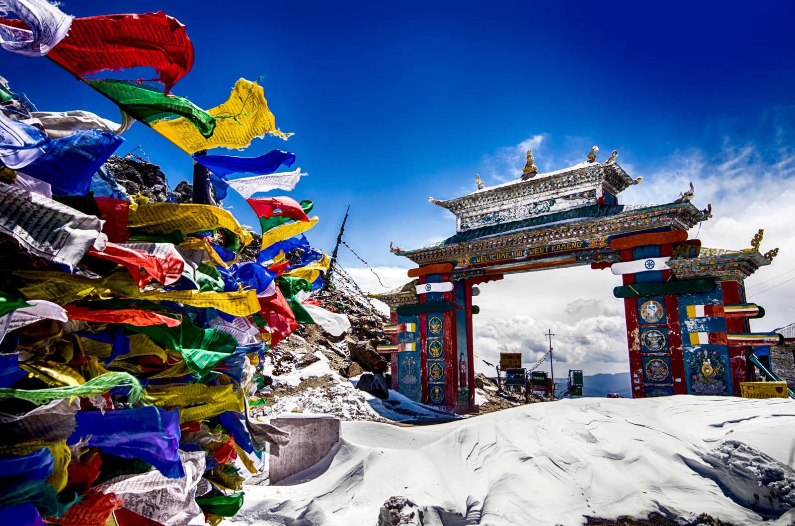
The 600-Year Bridge Connection: The route to Tawang includes crossing the ancient Chagzam Bridge, built by the Tibetan monk-engineer Thangtong Gyalpo in 1420 AD. Walking across iron chains that have carried travelers for six centuries, I felt the weight of continuity—generations of pilgrims, traders, and seekers who followed the same path I was riding.
The bridge represents more than engineering achievement; it embodies the Buddhist principle of creating connections across barriers. Thangtong Gyalpo built over 100 bridges across the Himalayas, each one following his philosophy that spiritual practice includes practical service to community welfare.
Day 2: The Earthquake Lake Legend – Madhuri Lake at Bumla Pass
The climb to 15,200 feet at Bumla Pass tests both rider and machine, but the destination reveals one of nature’s most haunting transformations. Madhuri Lake, with its impossibly turquoise water and skeletal tree stumps rising from its surface, carries a legend of tragedy transformed into unexpected beauty.
The Catastrophic Origin: Local elders tell of a devastating earthquake in the 1950s that changed the mountain’s drainage patterns, flooding an entire valley and trapping a village beneath the rising waters. The dead trees standing in the lake are said to be the same trees that once shaded village homes.
Meeting Border Road Organization workers who maintain the treacherous route to Bumla Pass, I learned how this remote location gained international fame when Bollywood discovered its ethereal beauty for film shoots. The contrast feels surreal—a place born from geological catastrophe becoming a symbol of cinematic romance.
Border Reality: At Bumla Pass, the Indo-China border, Army jawans shared chai and stories of maintaining vigilance at one of the world’s most challenging frontier posts. Their hospitality at 15,200 feet, surrounded by peaks that disappear into clouds, demonstrates the human warmth that flourishes even in earth’s most extreme conditions.
The lake’s legend speaks to transformation—how devastating events can create unexpected beauty, how tragedy can become pilgrimage destination, how the earth’s most violent moments sometimes produce its most peaceful places.
Day 3: The Warrior’s Waterfall Legend – Jung Falls and Jaswantgarh
The final day’s legend carries the weight of recent history and personal heroism. Jung Falls, also known as Nuranang Falls, connects to stories of the 1962 Indo-China conflict and a local girl whose bravery became part of military folklore.
Jaswant Singh’s Stand: The day begins at Jaswantgarh War Memorial, where Lance Naik Jaswant Singh of the 4th Garhwal Rifles held his position alone for 72 hours during the 1962 war, using captured enemy weapons after his unit was ordered to withdraw. His solo defense became legendary among both Indian and Chinese forces.
Nuranang’s Story: The waterfall itself carries the legend of a local Monpa girl named Nuranang who helped Indian forces during the conflict, providing crucial intelligence about Chinese troop movements. When she was discovered and killed by enemy forces, the waterfall was renamed in her honor.
Standing before the 100-meter cascade that now powers the entire valley through its hydroelectric plant, the legend reveals layers of meaning. The same water that witnessed tragedy now provides electricity for homes, schools, and the very memorial that honors those who died defending this land.
Living Legacy: Meeting descendants of families who lived through the 1962 conflict, I learned how personal stories become community memory. Nuranang’s sacrifice isn’t just military history—it’s local identity, woven into daily life through the waterfall that bears her name and the power it generates.
View this post on Instagram
Cultural Deep Dive: Monpa Legends and Buddhist Stories
The Monpa Storytelling Tradition
The Monpa people of Tawang maintain oral traditions that transform landscape into narrative. Every significant geographical feature carries stories that serve multiple purposes: preserving community memory, teaching moral lessons, and creating spiritual connection to place.
Sacred Geography: In Monpa tradition, mountains, lakes, and waterfalls aren’t just natural features—they’re characters in ongoing stories that connect past events with present experience. The divine horse legend serves to sanctify the monastery’s location while teaching about recognizing divine guidance in natural signs.
Community Memory Through Story: The earthquake lake legend demonstrates how communities process trauma through narrative. By transforming catastrophic geological events into stories that acknowledge both loss and beauty, communities create frameworks for understanding how disaster can lead to unexpected gifts.
Buddhist Integration with Local Traditions
Tawang’s legends show how Buddhism integrated with local Monpa traditions without erasing indigenous storytelling. The monastery legends incorporate both Buddhist concepts of divine guidance and local understanding of animal spirits and natural signs.
Tantric Buddhism in Daily Life: The prayer wheels at Tawang Monastery aren’t just religious artifacts—they’re practical meditation tools that connect individual practice with community devotion. Spinning prayer wheels while circumambulating the monastery creates moving meditation that includes physical landscape in spiritual practice.
Photography Challenges: Capturing Legend and Landscape
High-Altitude Photography Considerations
Tawang’s elevation creates unique photographic opportunities and challenges that require adaptation of both technique and equipment.
Extreme Altitude Effects:
- Battery life decreases dramatically in cold, thin air
- UV radiation at altitude affects color balance, requires UV filters
- Rapid weather changes demand quick technical adjustments
- Thin atmosphere creates exceptional clarity but harsh contrasts
Monastery Photography Ethics:
- Always ask permission before photographing monks or religious ceremonies
- Understand that some areas may be off-limits to cameras
- Use natural light rather than flash in prayer halls
- Focus on architectural details and landscape context rather than intimate religious moments.
Technical Settings for Legend Locations
Tawang Monastery in Morning Mist:
- f/8-f/11 for sharp architectural details
- 1/125s to freeze prayer flag movement
- ISO 200-400 depending on mist density
- Use graduated neutral density filter for sky/building exposure balance
Madhuri Lake Ethereal Reflections:
- f/11-f/16 for maximum depth of field
- Polarizing filter essential for reducing surface reflections
- Golden hour lighting enhances turquoise water color
- Include dead tree stumps for scale and story context
Jung Falls Dynamic Water:
- 1/4s exposure for silky water effect with neutral density filter
- f/8 for sharp foreground and background
- Shoot from multiple angles to capture scale
- Include hydroelectric infrastructure to show modern connection
Practical Route Guide for Legend Seekers
Border Area Requirements
Tawang’s location near international borders requires specific documentation and planning that differs from typical Indian domestic travel.
Essential Permits:
- Inner Line Permit (ILP) mandatory for all travelers
- Available online or at designated offices in Guwahati
- Valid for specific duration, route modifications require new permits
- Carry multiple copies and valid photo identification
Detailed Route with Legend Context
Day 1: Guwahati to Tawang (320 km, 8-10 hours)
- Route: NH-27 via Tezpur and Bomdila
- Legend Stop: Chagzam Bridge (27.1847° N, 92.0731° E)
- Key Challenge: High-altitude acclimatization after rapid elevation gain
- Accommodation: Limited options in Tawang, book advance
Day 2: Tawang to Bumla Pass to Madhuri Lake (160 km round trip)
- Bumla Pass: 15,200 feet, Indo-China border
- Special Requirement: Military escort sometimes required
- Weather Warning: Conditions change rapidly at extreme altitude
- Legend Context: Earthquake lake formation and Bollywood connection
Day 3: Tawang to Jung Falls to Jaswantgarh (80 km, full day exploration)
- War Memorial: Jaswantgarh (27.1456° N, 91.8734° E)
- Waterfall Access: Jung Falls viewpoint and base
- Historical Context: 1962 conflict sites and preserved bunkers
- Return Options: Same day or continue to Bomdila
High-Altitude Riding Preparation
Motorcycle Considerations:
- Royal Enfield Himalayan ideal for these conditions
- Ensure recent service and spare parts availability
- Fuel planning critical—limited stations above 10,000 feet
- Emergency repair kit essential for remote sections
Personal Preparation:
- Acclimatization time crucial for altitude over 10,000 feet
- Comprehensive weather gear for rapid condition changes
- Emergency supplies including food, water, and communication devices
- Travel insurance with high-altitude evacuation coverage
Legend Keepers: Voices of Living History
Lobsang Tenzin – The Monastery Storyteller (Tawang)
Meeting Lobsang, a 64-year-old monk who has spent 40 years at Tawang Monastery, provided insights into how ancient legends remain alive in daily practice. His understanding of the divine horse story goes beyond folklore to practical spiritual guidance.
“Western people think legends are just stories,” he explained while showing me 400-year-old manuscripts. “For us, legends are maps—they show us how to recognize divine guidance when it appears in ordinary life.”
His perspective on the monastery’s location revealed layers of meaning I’d missed. The divine horse didn’t just choose a beautiful spot—it chose a location where natural features create optimal conditions for meditation and community life.
Pemba Sherpa – The Border Guide (Bumla Pass)
Spending time with Pemba, a local guide whose family has lived in the border regions for generations, revealed how geological legends help communities process traumatic events. His grandfather witnessed the earthquake that created Madhuri Lake.
“Before earthquake, was green valley with village, animals, many families,” he shared while we sat beside the turquoise waters. “Grandfather said first they mourned what was lost. Then they saw beauty in what was created. Both feelings are true.”
His perspective on the lake’s transformation from tragedy to tourist destination showed how communities adapt to change while maintaining connection to memory.
Lessons Learned: Stories as Navigation
Legend as Cultural GPS
This journey taught me that local legends serve as sophisticated navigation systems for understanding both physical geography and cultural meaning. The stories don’t just entertain—they encode practical wisdom about weather patterns, seasonal changes, and community values.
Sacred Site Recognition: Learning to recognize locations through their associated legends created different relationship with landscape. Instead of seeing scenic stops, I began recognizing places where communities had invested spiritual and emotional meaning across generations.
Historical Layering: Each legend revealed how communities layer meaning over time. Buddhist stories overlay local Monpa traditions, which incorporate geological events and historical conflicts, creating rich narrative landscapes that connect past and present.
Community Memory in Action
Witnessing how legend keepers like Lobsang and Pemba maintain and share stories revealed the active work required to keep cultural memory alive. These aren’t passive traditions but dynamic practices that require conscious preservation and adaptation.
Living Storytelling: The most powerful realization was understanding that legends aren’t fixed historical accounts but living narratives that communities continue to shape through retelling, reinterpretation, and connection to contemporary experience.
Call to Legend Seekers
Who Should Follow These Stories
- Cultural Explorers: Travelers interested in how communities create meaning through landscape
- Spiritual Seekers: Those drawn to places where sacred and natural intersect
- History Enthusiasts: People wanting to understand how personal stories become community memory
- High-Altitude Adventurers: Experienced mountain riders ready for extreme conditions and border area protocols
Preparation for Legend Immersion
- Cultural Preparation: Learn basic Monpa greetings, understand Buddhist monastery etiquette, research local storytelling traditions
- Mental Preparation: Approach with respect for active spiritual sites and military memorial areas
- Physical Preparation: Serious high-altitude conditioning, cold weather gear, emergency preparedness for remote areas
The Transformation That Awaits
You’ll return with understanding of how landscape and story interconnect, appreciation for communities that maintain oral traditions, skills for recognizing sacred geography in natural features, and membership in the select group of travelers who have experienced India’s northeastern frontier.
Most importantly, you’ll carry the realization that the most meaningful destinations aren’t just places—they’re stories that continue to unfold through every person who makes the journey with respect and attention.
As Lobsang told me during evening prayers at the monastery: “Divine horse showed lama where to build monastery. Every traveler who comes here continues that story. Question is—what story will you carry forward?”
Essential Appendices
Border Area Protocols
- Inner Line Permit: Apply minimum 48 hours in advance, carry originals plus copies
- Military Checkpoints: Cooperation and patience required at multiple verification points
- Photography Restrictions: No photos of military installations, some monastery areas off-limits
- Communication: Limited cell coverage, inform contacts of detailed itinerary
High-Altitude Safety
- Acclimatization: Minimum 24-48 hours in Tawang before high-altitude excursions
- Medical Preparation: Altitude sickness medication, emergency evacuation insurance
- Weather Monitoring: Conditions change rapidly, flexibility essential for safety
- Emergency Contacts: Local authorities, medical facilities, military assistance
Cultural Sensitivity
- Monastery Etiquette: Remove shoes, clockwise circumambulation, respectful photography
- War Memorial Respect: Appropriate dress, respectful behavior, no inappropriate photography
- Local Communities: Ask permission before photographing people, respect privacy
- Environmental Responsibility: Pack out all waste, respect fragile high-altitude ecosystems
Emergency Contacts
- Tawang Police: +91 3794 223234
- Tourist Helpline Arunachal: +91 360 2244624
- Medical Emergency Tawang: +91 3794 223048
- Border Road Organization: Emergency road conditions
Ready to discover that GPS shows routes, but legends show souls? Tawang’s three ancient stories await those willing to listen to the land itself.
Contact Zara: @zaraonwheels
This legend chronicle represents one rider’s experience during specific conditions. Tawang requires serious preparation for high-altitude, border area travel—always verify current permit requirements, weather conditions, and respect both military protocols and sacred site guidelines. The stories will be there tomorrow—ensure you are too.